
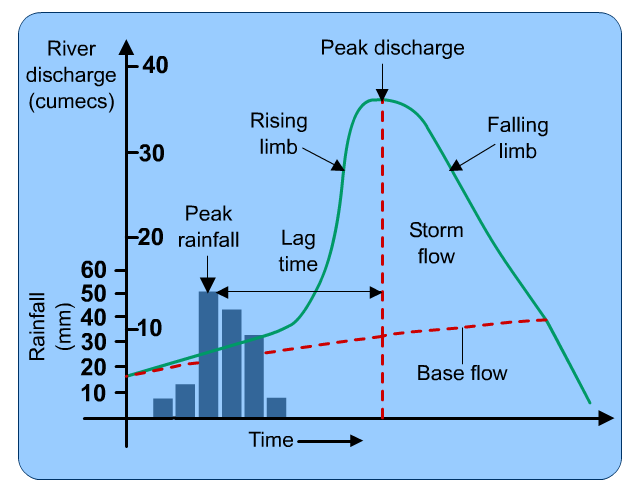
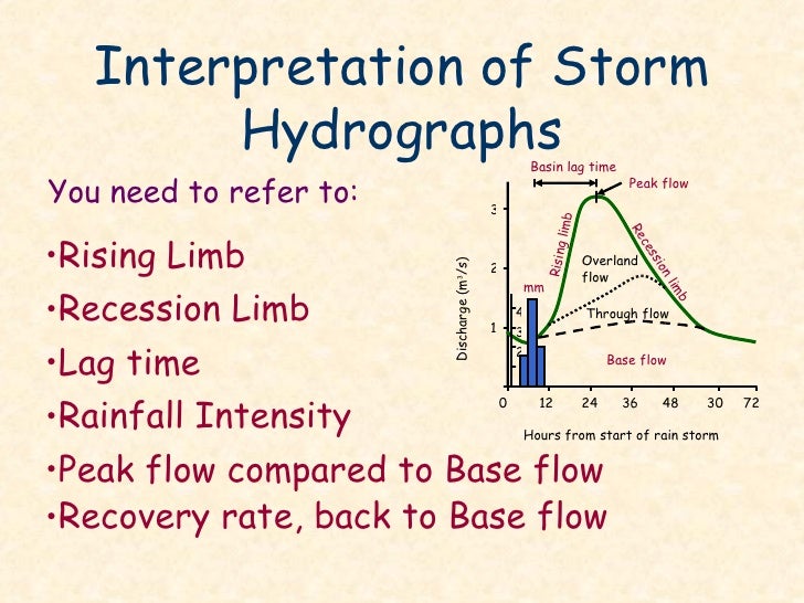
Hydrographs
A hydrograph or storm hydrograph is a type of graph that shows how a rivers' discharge responds to a period of precipitation. Discharge is measured in one point (using the units cumecs), but precipitation is measured over the whole drainage basin. On the hydrograph, precipitation is shown using a bar graph and discharge is shown using a line graph.
Peak rainfall: The highest rainfall (usually measured in mm) during a storm.
Peak discharge: The highest discharge as a result of a storm event.
Lag time: The period of time between peak rainfall and peak discharge
Response time: The time between the first rain falling and the first change in discharge.
Rising limb: The period of time that the river is experiencing an increase in discharge.
Falling or recessional limb: The period of time that a rivers' discharge is falling after a storm event and returning to its normal flow.
Bankfull discharge: The maximum amount of discharge that a river can hold before it burst its banks and floods.
As the period from the initial storm increases, throughflow and baseflow will become increasingly more important in contributing to a rivers' discharge. Initially surface run-off will be the most important factor in contributing to a rivers' discharge because this is the quickest way for rainfall to enter a river.
Source: http://greenfieldgeography.wikispaces.com/Hydrographs
Source: http://www.thegeographeronline.net/freshwater---issues-and-conflicts.html
Video: Complete storm hydrograph in small stream channel.
Source: http://www.thegeographeronline.net/freshwater---issues-and-conflicts.html
The amount and intensity of the rainfall is not the only factor influencing the shape of the hydrograph. Below are other influences:
Source: http://www.bbc.co.uk/staticarchive/da755ddae56f0e6109048a44830b2efe964e23b8.png
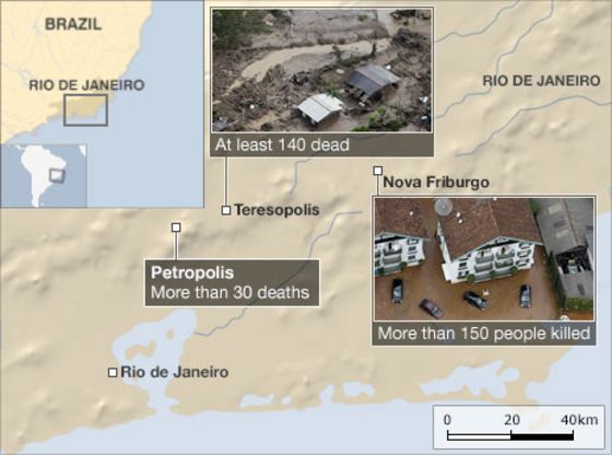
Flood and landslides in Rio de Janeiro, Brazil - 2011
Source: http://www.bbc.com/news/world-latin-america-12180079
Physical factors affecting flood risk
- Steep drainage basins and valley sides. Much of Rio and the surrounding area is very mountainous. The steep valleys means that any rainfall reaches streams and rivers very quickly causing flash floods.
- High levels of precipitation. It is estimated that areas around Rio received the equivalent of a months rainfall in just two days, 11th January and 12th January.
- Brazil experiences a tropical climate and the south east of Brazil (around Rio de Janeiro) can experience over 4 metres of rain a year. The majority of the rains falls during the summer months (including January). This means that during the summer the ground remains largely saturated, reducing infiltration rates and increasing surface run-off.
- La Nina - During 2010 and early 2011 Brazil has suffered increased rainfall caused by La Lina. La Lina is an oceanic-atmospheric system that can cause increased rainfall by changing temperatures.
- Mudslides. Although many of the causes of mudslides were human (deforestation, building on marginal land) the mudslides themselves were a secondary hazard of the flood water. The flood water saturated the ground, increasing the stress on the slopes and causing mudslides to happen.
- Impermeable rock tends to increase the risk of flooding because less precipitation can infiltrate.
- Some countries suffer snow melt during late spring and summer, this can greatly increase the discharge of rivers and therefore increase the risk of flooding.
- Tropical storms can increase precipitation and also create storm surges which can increase the height of the water table and increase the risk of flooding.
- Sedimentation of rivers either naturally or because of human actions can cause rivers' cross-sections to become smaller and increase the risk of flooding.
Other factors affecting flood risk
Urbanization
- Urbanization can increase flooding, because the construction of roads and buildings increase the amount of impermeable surfaces.
- Building on marginal land. Increasing rates of rural-urban migration have meant that more and more people are building on marginal land. Marginal land includes floodplains and steep slopes which are unsuitable for settlement building.
- No building regulations. Most settlements built on marginal land are informal. This means that residents have built the houses themselves, using any available material. The houses will be weak with no real foundations so are very vulnerable during times of flood. In Brazil and Rio many of these informal settlements are called favelas. Most of these settlements will not have any drainage. This will increase the saturation of soil and increase the likelihood of floods.
- Population density. Most informal settlements have extremely high population densities. These high population densities mean that any floods are going to affect a larger number of people.
- Poor transport and communication. Poor areas were worse affected, which meant many people received no warning of the floods because they did not have access to media sources. In addition they would have had little opportunity to live the area, even if they did know. The poor transport and communication also meant that rescue efforts were made much more difficult.
Source: http://greenfieldgeography.wikispaces.com/Floods
Deforestation
- Deforestation of hillsides. This reduces the strength of hills by removing route systems. It also reduces the amount of interception and transpiration. The reduced interception and transpiration means that the soil becomes saturated more quickly increasing surface run-off and the stress on slopes. This increased stress can cause landslides to happen.
Channel modification
- Protecting one area with embankments or river straightening can cause increased risk of flooding further downstream.
Source: http://greenfieldgeography.wikispaces.com/Floods
Attempts at flood prediction
River forecast
Flood mitigation
Channel Enlargement (widening/deepening):Making the width and depth of the river wider and deeper to increase its cross-sectional area.
Advantages: By enlarging the cross-sectional area you are increasing the bankfull discharge of the river along with its hydraulic radius. This will increase the velocity of the river and reduce the chances of it flooding in the immediate area by moving the floodwater further on downstream.
Disadvantages: If buildings are built up to the river bank it might not be possible to enlarge the channel. Also the process can be expensive and can cause problems to areas downstream who are receiving more flood water quicker, but with an un-enlarged channel.
Channel Straightening: Removing meanders from a river to make the river straighter.
Advantages: By removing meanders the velocity of the water through a settlement will increase. This will stop a backlog of water and should reduce the risk of flooding. It also improves navigation.
Disadvantages: By changing the course of the river, you might remove flowing water from industries that depend on it. There might also be building that have to be demolished to allow straightening. Again it is expensive and may cause flooding problems downstream.
Flood Relief Channels: Building new artificial channels that are used when a river nears bankfull discharge.
Advantages: They take the pressure off the main channels when floods are likely therefore reduce flood risk.
Disadvantages: It can be hard find land to build relief channels, they are expensive and when empty can become areas to dump rubbish, etc. If river levels rise significantly it is also possible for relief channels to flood as well.
Artificial Stores: Creating reservoirs or lakes that can store excess water in times of flood.
Advantages: They can remove pressure of the main channel and can become new habitats and serve other purposes e.g. leisure, drinking water.
Disadvantages: Building dams, sluices, diversion channels are all expensive. They also involve flooding areas of land which may be hard to find near large vulnerable urban populations.
Flood Embankments (levees): Like levees these increase the channel depth of a river, raising its bankfull discharge and reducing the risk of flood.
Advantages: They increase the cross-sectional area of the river and therefore its hydraulic radius. This should reduce the risk of flooding.Disadvantages: Like in New Orleans under extreme conditions, embankments may fail causing even bigger problems. They are expensive to build and again may cause problems downstream.
Controlled Flooding: Allowing low value land e.g. farmland to flood, therefore protecting higher value areas.
Advantages: By allowing the river to flood naturally you are taking the pressure of high value areas, you are letting the river behave more naturally and it adds alluvium to the floodplain.
Disadvantages: You have to make the decision what is worth protecting which is always going to upset someone. You also have to protect areas that you don't want to flood which costs money (cost benefit analysis)
Afforestation / Reforestation:Simply planting more trees in a drainage basin.
Advantages: This is a natural process, increasing the amount of interception, transpiration and root uptake. People would not normally protest against trees being planted.Disadvantages: It is not possible to cover the whole drainage basin in trees, so if it rains in an area with no trees, then there is no reduction in flooding. Also most trees lose there leaves in autumn and winter reducing interception in those months.
Flood Proofing: This is making property less vulnerable to flooding or flood damage. This might be temporary like using sandbags or design by removing carpets downstairs.
Advantages: This can be done on an individual level and can be relatively cheap. Temporary protection can be removed under normal circumstances so it does not change the aesthetics of properties.
Disadvantages: Temporary defences can usually only protect against minor floods. Not everyone will be happy with having to redesign their houses.
Insurance: Although it doesn't prevent flooding, it can help individuals and industries to recover and protect against future flooding.
Advantages: It helps individuals and settlements to recover after flood events and may help them protect property and be less vulnerable in the future.
Disadvantages: They do not actually prevent flooding. Not everyone can afford insurance and insurance companies may not insure high risk areas.
Land Use Planning (zoning): Mapping areas by looking at there likelihood to flood and then only building low value uses on areas with high flood risk.
Advantages: Very good at removing high value areas and high density populations from hazardous areas.
Disadvantages: It is not always possible to change land uses that already exist in an area. You have to decide what size flood to map for e.g. a once in ten year flood or once in one hundred year flood. Often poor will still choose to live on marginal land.
Contour, Ploughing and Strip Cultivation: Either ploughing with the contours creating temporary surface stores or leaving vegetation to increase interception and transpiration
Advantages: Contour ploughing is simply a cheap and easy change in existing farming methods, Keeping vegetation is natural and relatively cheap.Disadvantages: Won't protect against big floods and farmers may not be happy giving up farmland, simply to grow trees.
Interception Channels: These are channels that divert a rivers' discharge around settlements. The old channel remains but with a smaller discharge.
Advantages: They remove pressure of the main river and areas of high land value. They may also develop into new habitats for plants and animals.Disadvantages: They are expensive, may flood themselves in times of heavy floods and may restrict future urban
Settlement Removal: Moving settlements from high risk flood areas to less vulnerable locations often on higher land.
Advantages: Is probably the most effective because you remove high value property and humans from vulnerable areas.Disadvantages: It is usually not practical to move whole settlements, because of the cost and the problems of finding alternative locations. Also many settlements depend on water for their survival.
Dams: Often built as part of a multipurpose scheme, they create artificial stores which can hold water in times of increased precipitation.
Advantages: They can store large amounts of water and can be used for other purposes.Disadvantages: If rain is downstream of the dam then they have no effect. In large flood events they are vulnerable to breaking and are expensive to build.
Wing Dykes: Barriers placed out into a river, these can be used to divert the cause of rivers by shifting the thalweg of rivers. This may move the channel away from high value areas.
Advantages: They can move the main channel from vulnerable areas to protect high value areas.
Disadvantages: They are expensive to build and during big flood events the flood water may go over the wing dykes. Also if there is property on both sides of a river, which side do you protect.
Electronically Controlled Sewers: Advanced sewers which can control the flow of rain water to stop increased discharge into rivers and therefore flooding.
Advantages: They can be very effective at controlling smaller floods. They are underground so do not cause any visual pollution.Disadvantages: This involves a complete redesign of sewers. Sewers usually have to be increased in size and electronic sluices have to be added. They also have to be operated from a central command centre and with all electronically operated equipment can break. Also they might not be able to cope with large scale floods, so water has to be released into rivers anyway.
Channelization: The concreting of beds and banks.
Advantages: Reduces friction and increases velocity of river, removing water from the channelized area quicker. Bank erosion is also reduced.
Disadvantages: It is expensive and is not natural so vegetation and animal life will find it harder to grow and live. Flooding maybe caused downstream of the channelized area.
Dredging: The removal of material from the bed of the river deepening it.
Advantages: Channel cross-section is increased so the river can hold greater discharge. It can look more natural because no structures are built.
Disadvantages: Deposition can mean that dredging needs to happen regularly.
River bank conservation: Protecting the banks and sides of the river to reduce erosion. This can be done through planting vegetation.
Advantages: It looks natural, promoted wildlife and is relatively cheap compared to hard-engineering.
Disadvantages: During large flash floods vegetation can be easily removed.
River restoration: Returning a river to its natural state before it had been managed. This might involve removing channelization.
Advantages: This looks natural, is attractive and can attract wildlife. Can allow the floodplain to become more fertile.
Disadvantages: Can't protect against big floods and may have to coincide with zoning
Source: http://www.thegeographeronline.net/freshwater---issues-and-conflicts.html
No comments:
Post a Comment