
Managing coastal erosion and flooding
Hard engineering
Cliff-base management
Sea walls

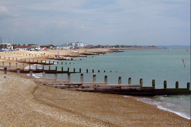
Aim: Seawalls are hard engineered structures with a primary function to prevent further erosion of the shoreline. They are built parallel to the shore and aim to hold or prevent sliding of the soil, while providing protection from wave action (UNFCCC, 1999). Although their primary function is erosion reduction, they have a secondary function as coastal flood defences. The physical form of these structures is highly variable; seawalls can be vertical or sloping and constructed from a wide variety of materials. They may also be referred to as revetments.
Strengths: The main advantage of a seawall is that it provides a high degree of protection against coastal flooding and erosion. A well maintained and appropriately designed seawall will also fix the boundary between the sea and land to ensure no further erosion will occur – this is beneficial if the shoreline is home to important infrastructure or other buildings of importance.
As well as fixing the boundary between land and sea, seawalls also provide coastal flood protection against extreme water levels. Provided they are appropriately designed to withstand the additional forces, seawalls will provide protection against water levels up to the seawall design height. In the past the design height of many seawalls was based on the highest known flood level (van der Meer, 1998).
Seawalls also have a much lower space requirement than other coastal defences such as dikes, especially if vertical seawall designs are selected. In many areas land in the coastal zone is highly sought-after; by reducing the space requirements for coastal defence the overall costs of construction may fall. The increased security provided by seawall construction also maintains hinterland values and may promote investment and development of the area (Nicholls et al., 2007b). Moreover, if appropriately designed, seawalls have a high amenity value – in many countries, seawalls incorporate promenades which encourage recreation and tourism.
When considering adaptation to climate change, another advantage of seawalls is that it is possible to progressively upgrade these structures by increasing the structure height in response to SLR. It is important however, that seawall upgrade does not compromise the integrity of the structure. Upgrading defences will leave a ‘construction joint’ between the new section and the pre-existing seawall. Upgrades need to account for this weakened section and reinforce it appropriately.
Provided they are adequately maintained, seawalls are potentially long-lived structures. The seawall in Galveston, Texas was constructed in 1903 and continues to provide coastal flood and erosion protection to the city to this day (Dean & Dalrymple, 2002).
Weaknesses: Seawalls are subjected to significant loadings, as a result of wave impact. These loadings increase with water depth in front of the structure because this enables larger waves close to the shoreline. Seawalls are designed to dissipate or reflect incoming wave energy and as such, must be designed to remain stable under extreme wave loadings. The effects of SLR, increased wave heights and increased storminess caused by climate change must all be taken into account.
Smooth, vertical seawalls are the least effective at dissipating wave energy; instead, the structures reflect wave energy seawards. Reflection creates turbulence, capable of suspending sediments (Bush et al., 2004), thus making them more susceptible to erosion. In a worst-case scenario, reflected energy can interact with incoming waves to set up a standing wave which causes intense scouring of the shoreline (French, 2001).
Scour at the foot of a seawall is a particular problem with vertical seawall designs. This phenomenon is caused by the process shown in Figure 2. Incoming waves impact the structure, causing water to shoot upwards. When the water falls back down, the force on the seabed causes a scour hole to develop in front of the structure. This can cause structural instability and is an important factor leading to the failure of many seawalls. As a result, seawall maintenance costs can be high (Pilarczyk, 1990a). A similar process occurs on inclined seawalls but in this case scour will occur away from the foot of the structure.
Sediment availability is also affected by seawall construction. The problem is caused by replacing soft, erodible shorelines with hard, non-erodible ones. While this protects the valuable hinterland, it causes problems in terms of sediment starvation; erosion in front of the seawall will continue at historic or faster rates but the sediment is not replaced through the erosion of the hinterland (French, 2001). This can cause beach lowering, which reduces beach amenity value and increases wave loadings on the seawall by allowing larger waves close to the shore.
Although seawalls prevent erosion of protected shorelines, where the seawall ends, the coast remains free to respond to natural conditions. This means that undefended areas adjacent to the wall could move inland causing a stepped appearance to the coast (French, 2001). The downdrift end of the seawall is also typically subjected to increased erosion as a result of natural processes (see Figure 3). This flanking effect can cause undermining and instability of the wall in extreme cases.
Because seawalls are immovable defences, they can also interfere with natural processes such as habitat migration which is naturally induced by sea level change. Seawalls obstruct the natural inland migration of coastal systems in response to SLR, therefore causing coastal squeeze. This process causes a reduction in the area of intertidal habitats such as sandy beaches and saltmarshes because these environments are trapped between a rising sea level and unmoving, hard defences.
In estuaries, seawalls also cause changes to the area inundated by the tides thus, reducing the available area for occupation by water on a high tide. With the same volume of water flowing into the estuary, the level of the water after seawall construction will be higher. This may mean areas in front of the defence remain submerged longer and by greater depths. In turn, this is likely to affect the distribution of vegetation and could increase tidal range upstream of the defence (French, 2001).
Another potential problem is overtopping. This occurs when water levels exceed the height of the seawall, resulting in water flow into areas behind the structure. Overtopping is not a continuous process but usually occurs when individual high waves attack the seawall, causing a temporary increase in water level which exceeds the structure height (Goda, 2000). If the structure is too low, excessive overtopping can remove considerable amounts of soil or sand from behind the wall, thus weakening it. Further, overtopping water saturates and weakens the soil, increasing pressures from the landward side, which can cause the foot of the structure to ‘kick out’ and collapse (Dean & Dalrymple, 2002). Overtopping will become increasingly problematic with SLR, increased wave heights and increased storminess.
As mentioned in the advantages section, seawalls increase security by reducing the risk of flooding and erosion. However, the coastal zone remains a high risk location not least due to the presence of residual risk. To combat unwise development of the coastal zone, future developments need to be carefully planned.
Additionally, by encouraging development, hard defences necessitate continued investment in maintenance and upgrades, effectively limiting future coastal management options. Although authorities may not have a responsibility to continue providing protection, the removal of defences is likely to be both costly and politically controversial (Nicholls et al., 2007b).
Seawalls also reduce beach access for handicapped people and for emergency services. This can be problematic if the beach fronting such structures is to be used for recreation. The appearance of seawalls can be aesthetically displeasing which can further negatively affect beaches dependent upon a tourist economy.
Source and more at: http://www.climatetechwiki.org/content/seawalls
Revetments

Aim: Revetments are concrete (or in some cases wooden) structures that are built along the base of a cliff. They’re slanted and act as a barrier against waves not too dissimilar to a sea wall. The revetments absorb the energy of the waves, preventing the cliffs from being eroded. Revetments can be modified so that they have rippled surfaces, which further help to dissipate the wave energy.
Strengths: Revetments are normally successful at reducing coastal erosion but they are expensive to build. Once built however, they don’t require as much maintenance as a sea wall. Rubble revetments are often used as reinforcement for seawalls which have been exposed due to the disappearance of the beach. Such reinforcement protects the foot of the seawall and minimizes the reflection.
Weaknesses: A revetment will fix the location of the coastline, but it will not arrest the ongoing erosion in the coastal profile, and the beach in front of the revetment will gradually disappear. A revetment, like a seawall, will decrease the release of sediments from the section it protects, for which reason it will have a negative impact on the sediment budget along adjacent shorelines.
Gabions

Aims: Gabions are quite simply bundles of rocks in a metal mesh. They’re placed at the base of a cliff in an attempt to reduce the impact of waves on the cliff and prevent the cliff from being undercut. They’re not particularly effective and they’re quite unsightly but they’re sure as hell cheap.
Strengths: Gabions and Renos have an advantage over traditional construction materials such as concrete because they are extremely strong and will not be washed away while at the same time being flexible enough to conform to ground movement. They are an ideal solution to flood control as they help dissipate and slow the water flow.
- Use of smaller rocks gives greater flexibility in design
- Less easy to erode
- Can use local beach material to reduce visual impact
Weaknesses:
- Unnatural appearance
- Unpleasant if mesh breaks - risk of injury
- Shorter lifespan than other techniques
- Ongoing maintenance costs
Groynes

Aims: Groynes are relatively soft hard engineering techniques. They’re low lying wooden walls that extend out to sea. The idea of groynes is to capture sand that moves down the beach via longshore drift and help build up a larger section of beach in front of an area that’s experiencing coastal erosion. The new beach will increase the distance that waves have to travel to reach the coast and, in the process, they’ll lose most of their energy, reducing their impact.
Strengths: 
Weaknesses: Groynes will remove a lot of the sand that’s present down-drift of the beach which will result in a thinner beach at this area. This, in turn, means that sections of the coast will be more exposed to erosion down drift of the groynes which can create new problems relating to coastal management.
Rock armor

Aim: Rock armor or rip-rap involves placing large boulders in front of a cliff or sea wall to absorb the energy of waves.
Strengths: Rock armor is a cheaper solution than seawalls to deflect the wave energy.
Weaknesses: Unattractive; small scale; my be removed during heavy storm.
Source: Nagle, G. and Cooke, B. Geography course companion. Oxford. 2nd edition.
Offshore breakwaters

Aims: Breakwaters are offshore concrete walls that break incoming waves out at sea so that their erosive power is reduced to next to none when they reach the coast.
A living shoreline approach for sand beach shorelines uses large, gapped stone structures strategically placed offshore. Offshore breakwater systems provide shoreline protection by intercepting incoming waves and creating stable pocket beaches between the fixed stone structures, or "headlands". The system includes beach nourishment and planting beach and dune vegetation. A wide sand beach provides an erosion buffer as well as valuable estuarine habitat for aquatic and terrestrial wildlife.
Strengths: Cheap to build
Source: Nagle, G. and Cooke, B. Geography course companion. Oxford. 2nd edition.
Weaknesses: Breakwaters are effective but they can be easily destroyed during a storm and they don’t look particularly nice.
Rock strongpoints

The groyne-like rock structures attached to the rock armor and protruding towards the sea are the strongpoints.
Aims: rocks dumped into sea to form a narrow artificial headland; these have replaced wooden groynes at Barton on Sea. Their aim is to control longshore drift of sediment in a similar way to wooden groynes and have proved to be more effective as they have a stronger structure to resist storm waves.
Strengths: relatively low costs; easy to repair.
Weaknesses: disrupts longshore drift; erosion downdrift.
Source: Nagle, G. and Cooke, B. Geography course companion. Oxford. 2nd edition.
Cliff-face strategies
Cliff drainage

Aims: steel barriers and drains put into a cliff to intercept the water movement through the cliff which causes mass movement.
Strengths:
- No build up on impermeable and saturated clays
- Hidden structures mean more attractive natural appearance
- Prevents landslides/mass movement
Weaknesses:
- Cliff is still open to wave erosion
Vegetating

Aims: Cliffs are covered in vegetation planted to help make them more stable and resistant to erosion.
It increases interception and reduces overland run-off.
Strengths: Relatively cheap.
Weaknesses: May increase moisture content of soil and lead to landslides.
Source: Nagle, G. and Cooke, B. Geography course companion. Oxford. 2nd edition.
Cliff regrading

Aims: Artificially reducing the cliff angle with bulldozers at the cliff behind the beach to reduce cliff height and slope angle, reducing mass movements.
Strengths:
- Cliff becomes more stable
- Less prone to unexpected movement
Weaknesses:
- May be impractical if valuable land use exists on cliff top
- Ongoing maintenance costs
Soft engineering
Offshore reef


Aims: This process of shore protection which is analogous to natural reefs or shoals and can be included under soft engineering approaches, which protects coast in an environmentally friendly and aesthetically pleasing manner.
Conventional hard approaches like construction of sea wall, groins, revetments, bulkhe ads and break waters may have a negative environmental impact modifying the shoreline. Using artificial reefs as shore protection measure we can come out with wave energy dissipation without creating much destructive effects on coastline and its species compared to hard engineering approaches. (Hartig et al., 2011 )
Source: http://indomareclim-nerci.in/publication/workshop2014/Workshops2014/Srineash_Artificial_reef.pdf
Strengths:
- allow the build up of sand due to the reduction in wave energy
- waves break further off shore and therefore reduce their erosive power
Weaknesses:
- may be removed by heavy storms
- difficult to install
Managed retreat
Aims: Managed retreat or managed realignment is a coastal management strategy that allows the shoreline to move inland, instead of attempting to hold the line with structural engineering. At the same time, natural coastal habitat is enhanced seaward of a new line of defense. This approach is relatively new but is gaining traction among coastal policy makers and managers in the face of increased coastal hazard risks. There is a growing recognition that attempting to “hold the line” in many places is a losing battle.
Strengths: Cost effective; maintains a natural coastline.
Weaknesses: Unpopular; political implications.
Source: Nagle, G. and Cooke, B. Geography course companion. Oxford. 2nd edition.
The "do nothing" approach
Aims: The easy option, deal with the effects of flooding and erosion as they come or just ignore them. This is generally what happens in areas where there’s no people, and so nothing of “value” (to the government) to protect.
Strengths: cost effective.
Weaknesses: Unpopular; political implications.
Source: Nagle, G. and Cooke, B. Geography course companion. Oxford. 2nd edition.
Red-lining
Aim: Withdrawal or prevention of planning permission for new development
Strengths: Cost effective in long term
Weaknesses: Unpopular with residents and business. Politically tough
Source:http://www.thegeographeronline.net/uploads/2/6/6/2/26629356/coastal_managemtn_holderness_2.pdf
Coastal management case study - Holderness, UK
Holderness Coast GCSE Geography Case Study
Conflicting pressures on coastlines: The Soufrière marine management area (SMMA)
Management of coral reefs
Coral reefs are facing unprecedented threats from a combination of local and global stressors. At the same time, coral reefs are increasingly recognized as a vital foundation for economic development, community well being and social resilience.
Effective management of coral reefs has become an important focus for coastal communities, and a range of strategies are available to help protect reef biodiversity and facilitate sustainable use.
Below are some key strategies for coral reef managers to address local stressors and build resilience of coral reefs in the face of global change. These strategies are important complements to marine protected area (MPA) management and are best implemented as part of an integrated management approach.
- Managing Local Stressors
- Marine Protected Areas
- Fisheries Management
- Marine Conservation Agreements
- Reducing Land Based Impacts
- Managing for Disturbance
- Ecological Restoration
- Managing for Social Resilience
- Managing for Ocean Acidification
- Integrated Approaches
- Measuring Effectiveness and Adaptive Management
Source and more at: http://www.reefresilience.org/coral-reefs/management-strategies/
Coral management case study - The great barrier reef

How the Reef is managed
The Great Barrier Reef Marine Park Authority (GBRMPA) is responsible for ensuring the Great Barrier Reef Marine Park — one of the world's greatest natural treasures — is protected for the future.
As a World Heritage Area, the Reef is recognised internationally for its outstanding universal value.
For 40 years we've managed this biologically diverse place and multiple-use area, using the best available scientific information and input from marine managers, researchers, experts and Traditional Owners.
Our work in managing the Marine Park is guided by a range of plans, policies, regulations and legislation, with the Great Barrier Reef Marine Park Act 1975 setting out our functions and responsibilities.
We directly manage activities in the Marine Park, implement plans and policies for Reef use and protection, and work with communities and industries that depend on a healthy Reef for recreation and their livelihoods.
Tourism, fishing, boating and shipping are all legitimate uses of the Marine Park.
Source and more at: http://www.gbrmpa.gov.au/managing-the-reef/how-the-reefs-managed
Management of mangrove swamps
Planning principles
Given the many types of products and services which might be obtained from forest and aquatic resources in mangroves, a multidisciplinary approach towards their management is essential. The following principles can be used as a guide when preparing management plans for mangroves.
- Wood, non-wood and aquatic resources are managed in an integrated way and used to meet local, regional or national needs. Managing natural resources to meet peoples' needs implies a knowledge of what people want. An assessment of needs and public participation is an integral part of the planning process. The importance of a resource supply is not only determined by its physical or biological characteristics but also by the priority that society places on its use. This prioritization among the management objectives should be clearly reflected in the management plan's activities.
- Plans must be objective oriented. When the problems or issues are understood, a set of objectives should be identified to address key issues. Objectives should be quantifiable targets that serve to focus management efforts and measure performance.
- Plans must try to achieve the greatest good for the greatest number of people in the long run. Minority interests must be weighed in relation to the general well-being of larger communities. In practice it is impossible to achieve complete or unanimous support for all the management objectives. Compromises between local level and national level interests are necessary.
- The ecological carrying capacity should never be exceeded and resource sustainability should be given high priority. This is a non-negotiable requirement, if sustainable production is to be achieved. This requirement should be given high priority in the management planning agenda and for example a code of conduct for responsible harvesting of given products (forest-based or aquatic) should be elaborated.
- The need for the conservation of biological diversity and wildlife should be recognized. This should be incorporated into the plan in relation to the scale of the management area. For small and/or highly fragmented areas, it is impractical to reserve large tracts of pristine vegetation for conservation purposes. Instead, the establishment of well-placed control plots may be more feasible.
- Planning is an on-going dynamic process. Planning must be flexible enough to accommodate shifts in demand/supplies and priorities. Because society's values change over time, planning is an on-going dynamic process.
- The plan must provide for improvements in data collection to reduce areas of uncertainty associated with an incomplete or weak information base. The ultimate objective may be achieved in phases, taking into account an improved information base over time and applying a conservative approach where the uncertainty is perceived to be great.
- The decision-making process must be visible and equitable. Involving the public in the decision-making process is necessary to promote local support and acceptance for integrated forest management planning. It is the duty of the forest service to explain to the public the implications of various decisions. Customary rights should be respected where possible. Decision-making should not marginalize the traditional incomes of local people nor their access to forest products without offering practical and acceptable alternatives.
- Planning functions and responsibilities. The responsibility for planning functions should be clearly spelt out at different levels, from the local forest management unit level towards the national level.
Mangrove management case study - Kenya

Exclusive economic zones (EEZ)
An Exclusive Economic Zone (EEZ) is a concept adopted at the Third United Nations Conference on the Law of the Sea (1982), whereby a coastal State assumes jurisdiction over the exploration and exploitation of marine resources in its adjacent section of the continental shelf, taken to be a band extending 200 miles from the shore.

Dispute case study - The Falkland Islands' Disputed Seas
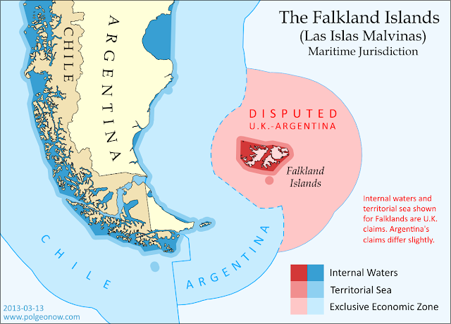
The Falkland Islands are administered by the U.K. as an overseas territory, but are also claimed based on historical arguments by Argentina, which calls them "las Islas Malvinas". Both countries have signed and ratified the United Nations Convention on the Law of the Sea (UNCLOS), which defines ownership and legal rights for the waters surrounding coastal countries.
Although the waters beyond the territorial sea are not considered part of the country itself, the country still has some legal rights over the surrounding ocean, up to a maximum distance of 200 nautical miles from the coast or internal waters. This is called the "exclusive economic zone", and here countries can control the harvesting of resources, scientific research, and environmental protection. When two countries are less than 400 nautical miles apart, they have to come to an agreement about where to draw the border of their EEZs (the default is normally to draw a line halfway between the two coasts).
The Falklands are indeed less than 400 nautical miles from mainland Argentina, but the Argentine government doesn't consider this to be a problem, because they consider both the mainland EEZ and the Falkland EEZ to be theirs. The U.K. also claims the waters around the Falklands (though it calls them a "fishery conservation zone" instead of an EEZ), but draws its line short of the halfway point between the islands and Argentina. This might be intended as a show of modesty, though Argentina isn't flattered, since it doesn't think the U.K. should be there in the first place.
Who Really Controls the Seas of the Falkland Islands?
Actual control of these seas follows the U.K.'s claims, since that's the country that actually controls the islands. Argentina insists this is illegal, and even temporarily occupied the islands in 1982; but it's unlikely control will change any time in the near future, since the U.K. insists it won't go against the will of the islanders (most of whom are proudly British, and many of whom have bad memories of Argentina from the 1982 war).
No comments:
Post a Comment