
Characteristics of urban places
Site, situation, shape and function

There are a huge number of factors that have to be considered when trying to locate a new settlement. These can be grouped into four broad headings: climatic, economic, physical and traditional. The diagram below should give you an idea of how each one plays a part in the location of a settlement.

Site
The site is the actual location of a settlement on the earth and is composed of the physical characteristics of the landscape specific to the area. Site factors include things like landforms (i.e. is the area protected by mountains or is there a natural harbor present?), climate, vegetation types, availability of water, soil quality, minerals, and even wildlife.
Historically, these factors led to the development of major cities worldwide. New York City, for example, is located where it is because of several site factors. As people arrived in North America from Europe, they began to settle in this area because it was a coastal location with a natural harbor. There was also an abundance of fresh water in the nearby Hudson River and small creeks as well as raw materials for building supplies. In addition, the nearby Appalachian and the Catskill Mountains provided a barrier to movement inland.
The site of an area can also create challenges for its population and the small Himalayan nation of Bhutan is a good example of this. Located within the world's highest mountain range, the terrain of the country is extremely rugged and hard to get around. This, combined with the incredibly harsh climate in many areas of the country has made much of the population settle along rivers in the highlands just south of the Himalayas.
In addition, only 2% of the land in the nation is arable (with much of it located in the highlands) making living in the country highly challenging.
Situation
Situation is defined as the location of a place relative to its surroundings and other places. Factors included in an area's situation include the accessibility of the location, the extent of a place's connections with another, and how close an area may be to raw materials if they are not located specifically on the site.
Though its site has made living in the nation challenging, Bhutan's situation has allowed it to maintain its policies of isolation as well as its own highly separated and traditionally religious culture.
Because of its remote location in the Himalayas getting into the country is challenging and historically this has been beneficial because the mountains have been a form of protection. As such, the heartland of the nation has never been invaded. In addition, Bhutan now controls many of the most strategic mountain passes in the Himalayas including the only ones into and out of its territory, leading to its title as the "Mountain Fortress of the Gods."
Like an area's site, however, its situation can also cause problems.
For example, Canada's Eastern Provinces of New Brunswick, Newfoundland and Labrador, Nova Scotia, and Prince Edward Island are some of that country's most economically downtrodden areas due in large part to their situations. These areas are isolated from the rest of Canada making manufacturing and the little agriculture possible too expensive. In addition, there are very few close natural resources (many are off the coast and due to maritime laws the government of Canada itself controls the resources) and many of the traditional fishing economies they did have are now crashing along with the fish populations.
The Importance of Site and Situation in Today's Cities
As shown in the examples of New York City, Bhutan, and Canada's East coast, an area's site and situation played a significant role in its development both within its own boundaries and on a world stage.
This has occurred throughout history and is part of the reason why places like London, Tokyo, New York City, and Los Angeles were able to grow into the prosperous cities that they are today.
As nations around the world continue to develop, their sites and situations will play a large role in whether or not they will be successful and though today's ease of transportation and new technologies such as the Internet are bringing nations closer together, the physical landscape of an area, as well as its location in relation to its desired market, will still play a large role in whether or not such areas will grow to become the next great world city.
Function and land use
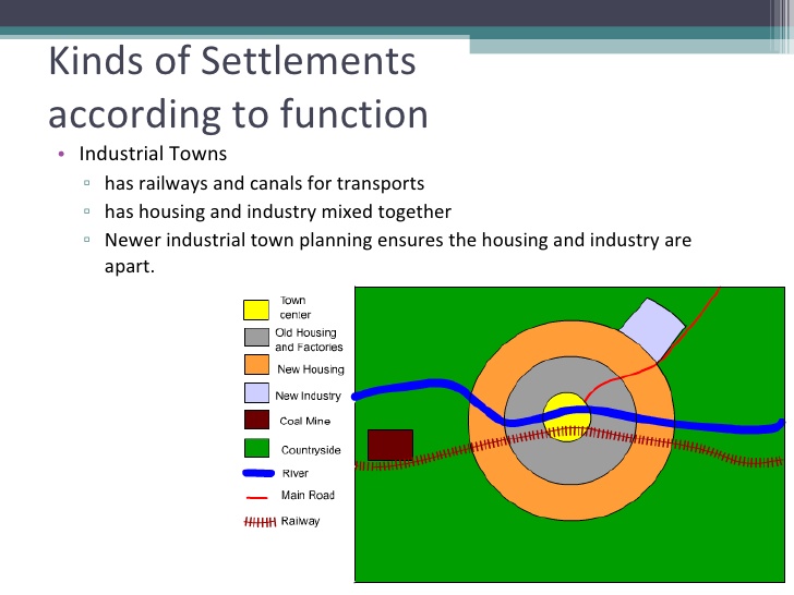
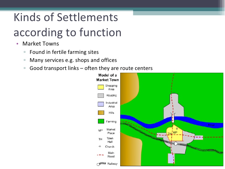
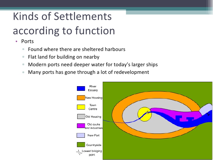
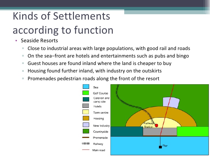
What do the models for different function towns have in common?
Land is used in a number of ways in urban areas. It may be:
residential – where people live
industrial – manufacturing industries that process raw materials
for services – education, health care, retail, entertainment
open space – parks, gardens, sports facilities, rivers
for recreation – including open space, sports centres, playgrounds, sports stadia
transport routes.
Source: IB Geography: Course Book 2nd edition: Oxford IB Diploma Program
Hierarchy of settlements
The hierarchy of different settlements is defined based on a number of characteristics:
Source: IB Geography: Course Book 2nd edition: Oxford IB Diploma Program

Source: Codrington, S. (2017). Planet geography - Themes. 2nd edition. Sydney: Solid Star Press.
Megacities
A megacity is an urban area that contains more than 10 million residents.


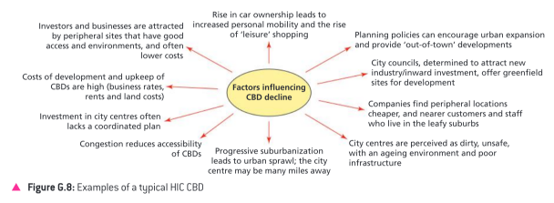
Factors affecting the pattern of urban economic activities
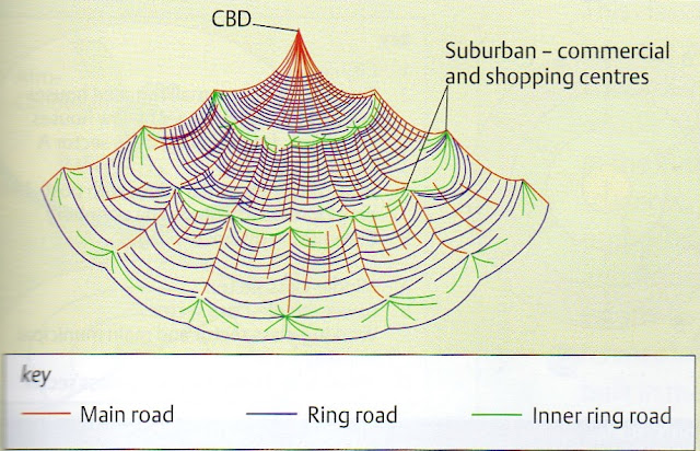
The central business district
The CBD or Central Business District is the focal point of a city. It is the commercial, office, retail, and cultural center of the city and usually is the center point for transportation networks.

Source: IB Geography: Course Book 2nd edition: Oxford IB Diploma Program
The Peak Land Value Intersection
The CBD is home to the Peak Land Value Intersection in the city. The Peak Land Value Intersection is the intersection with the most valuable real estate in the city. This intersection is the core of the CBD and thus the core of the metropolitan area. One would not typically find a vacant lot at the Peak Land Value Intersection but instead one would typically find one of the city's tallest and most valuable skyscrapers.
The CBD is often the center of a metropolitan area's transportation system. Public transit, as well as highways, converge on the CBD, making it a very accessible to those who live throughout the metropolitan area.
On the other hand, the convergence of road networks in the CBD often creates overwhelming traffic jams as commuters from the suburbs attempt to converge on the CBD in the morning and return home at the end of the work day.
The CBD of a city may change over time. The pictures below show three central business areas in São Paulo, Brazil - from the oldest to the most recent.

Source: IB Geography: Course Book 2nd edition: Oxford IB Diploma Program
Bid rent theory
The concept of bid rent is vital to models of land use and as such, it is important to have an understanding of it to know how urban areas may grow. Bid rent is the value of land for different purposes. The land at the centre of the city is the most expensive due to its accessibility (by public transport) and the small amount of land actually available (hence the high-rise buildings). As such, land prices tend to decrease away from the CBD, although there are peaks in particularly desirable areas (near main road intersects). This type of land-use is also recognised in Burgess’ model.

Source: IB Geography: Course Book 2nd edition: Oxford IB Diploma Program

Source: Codrington, S. (2017). Planet geography - Themes. 2nd edition. Sydney: Solid Star Press.
Maximizing profit in high demand retail/office and residential areas often means verticalization:
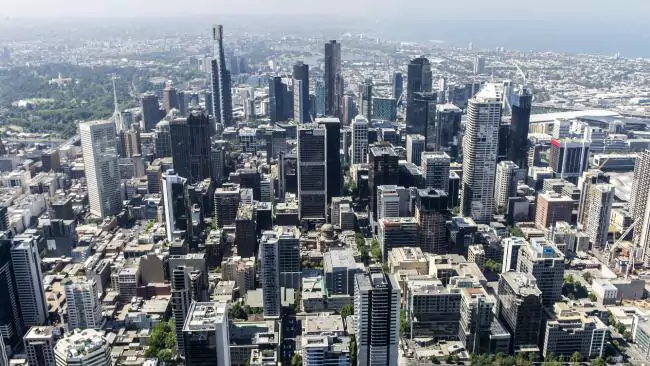 |
| Melbourne, Australia. |
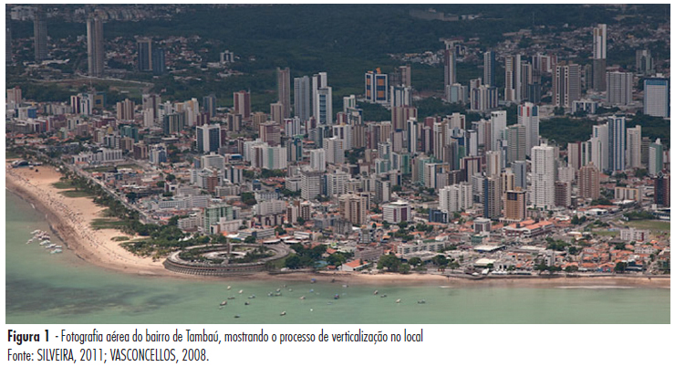 |
| João Pessoa, Brazil. |
Retail and land use
Type and size of retail businesses vary geographically on account of concentration and either they offer low or high-order goods.
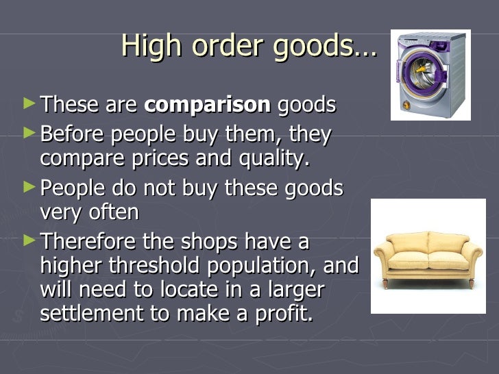
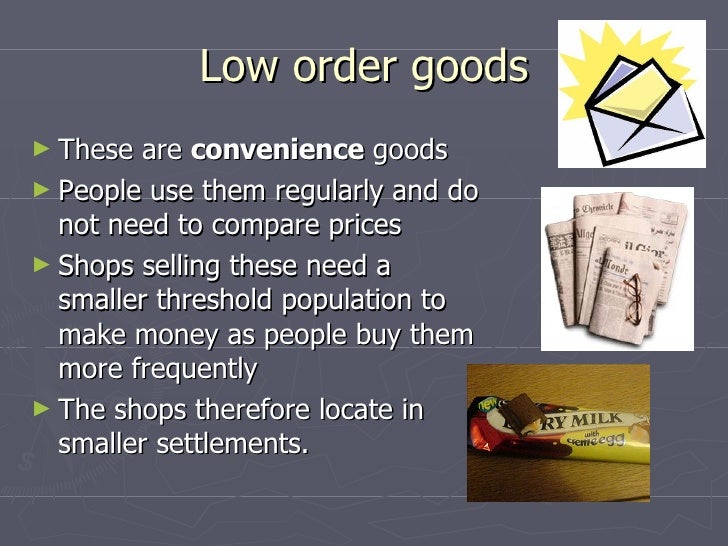
Low-order goods concentrated tend to be found more frequently in neighborhood stores and shopping parades. High-order goods are more often found in high street shops and department stores. Out-of-town superstores and retail parks may sell both types but the prices need to need to be worth the trip in the case of low-order goods.
 |
| Via Veneto in Rome (Italy) is an example of a high street shops location where comparison goods are sold |
 |
| Low-order goods neighborhood shops on Massachusetts Avenue in Cambridge, USA |
 |
| ASDA superstore in Eastleigh, England |
Industrial activity and land use
There are a number of locations for industrial zones in most cities. These
include:
- inner-city areas close to railways and/or canals, for example dock- related industries such as imports and exports
- brownfield suburban sites close to airports
- sites away from residential locations, for polluting industries that may be required to locate outside the urban area.
Source: IB Geography: Course Book 2nd edition: Oxford IB Diploma Program
 |
| Inner city factory in Dundee, Scotland |
 |
| Battersea Power Station in London, England |
 |
| Chevron refinery in Richmond, USA |
Factors affecting the pattern of residential areas
Physical factors
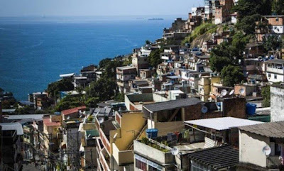
Many physical aspects may influence the land price and therefore the type of residential area of a given location. For instance, in Rio de Janeiro, Brazil, the flat areas were occupied by the wealthiest and either early gentrification or late coming forced the low income residents to occupy hills and their steep slopes, which is why in rio the word 'morro' (in English, hill) is a synonym for slum or squatter settlement.
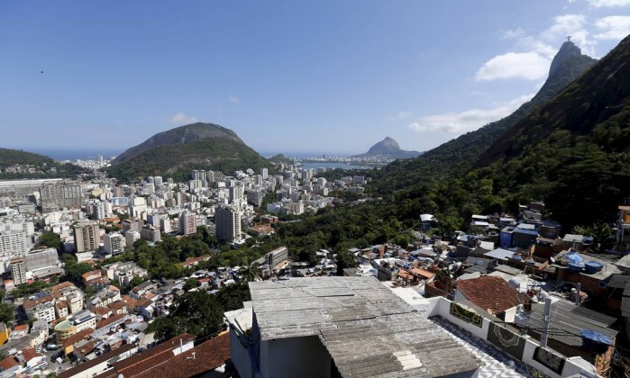 |
| This picture was taken from Morro Dona Marta which is a squatter settlement located near Botafogo, a well-known high income neighborhood of Rio de Janeiro |
The presence of freshwater bodies such as rivers and lakes may increase but also lower the land value of an area. In high income countries for instance these areas are sought for their pleasant views and recreational opportunities. On the other hand, it is not uncommon to find heavily polluted water bodies in cities of lower income countries. These areas are also often prone to flooding which makes their land value low and consequently they become low income residential areas.
 |
| Limmatquai bay area in Zurich, Switzerland |
 |
| Jardim Pantanal area in eastern São Paulo, Brazil. |
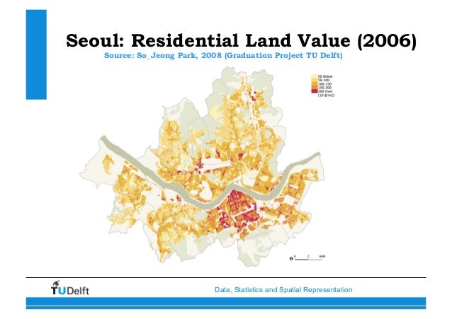
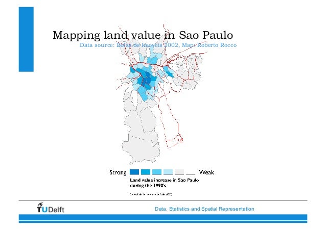
Land values
 |
| This map represents approximate land value in the Zhabei area in Shanghai, China |
Often times the highest land values are found in central locations and/or areas served with good transport links. However, in high income countries the suburban areas are becoming more and more densely populated due to their attractive features. In lower income countries, the poorer residential areas may be located on the outskirts of the city and therefore not be well served by a series of infrastructure services such as transport and communication for instance. Low income residential areas may also be located closed to the city center mainly due to proximity to work in order to reduce communing time. These areas are often squatter settlements.
Ethnicity
Specific ethnic groups may end up living in common neighborhoods either by choice or simply because their access to wealth may be limited. These are examples of positive and negative segregation. Chinatown in San Francisco, USA is an example of positive segregation.

The map below shows the percentage of the population per districts which ethnically identifies as black in São Paulo, Brazil.

Poverty, deprivation and informal activity in urban areas

Source: http://geographymonkey.com/uploads/3/5/2/1/35215747/web_of_deprivation.png
Measuring deprivation
A number of indices are used to measure deprivation. These include:
- physical indicators – such as quality of housing, levels of pollution, incidence of crime, vandalism, grafitti
- social indicators – including crime (reported and fear of); levels of health and access to health care;
- standards of education; proportion of population on benefits (unemployment, disability, free school
- meals); proportion of lone-parent families
- economic indices – access to employment; unemployment and underemployment; levels of income
- political indices – opportunities to vote and to take part in community organization.
Source: IB Geography: Course Book 2nd edition: Oxford IB Diploma Program
Average breadwinner income in household (in BRL) - 2010

Source: http://gesp.fflch.usp.br/node/194
Average breadwinner income in household (in BRL) - 2010
Source: http://gesp.fflch.usp.br/node/194
Formal employment by sector (Industry, commerce and services) - 2004

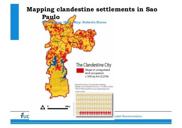
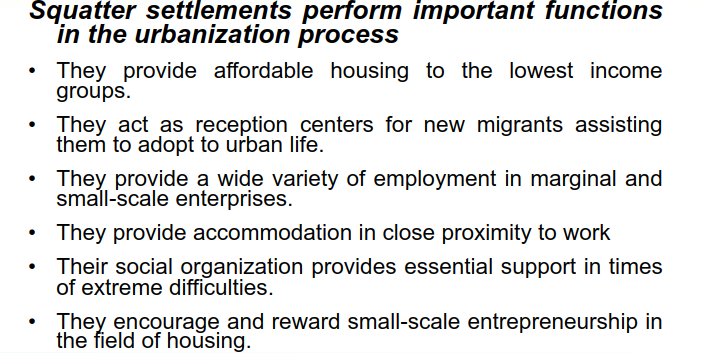
Slums and squatter settlements
Definition of a squatter settlement varies widely from country to country and depends on a variety of defining parameters. In general, it is considered as a residential area in an urban locality inhabited by the very poor who have no access to tenured land of their own, and hence "squat" on vacant land, either private or public.
‘Slum’, at its simplest, is ‘a heavily populated urban area characterized by substandard
housing and squalor’.21 This definition encapsulates the essential characteristics of slums: high
densities and low standards of housing (structure and services), and ‘squalor’. The first two
criteria are physical and spatial, while the third is social and behavioural. This spread of
associations is typical, not just for the definition of slums but also of our perceptions of them.
Dwellings in such settlements vary from simple shacks to more permanent structures, and access
to basic services and infrastructure tends to be limited or badly deteriorated.
The definition of the term ‘slum’ includes the traditional meaning – that is, housing areas that
were once respectable or even desirable, but which have since deteriorated as the original dwellers
have moved to new and better areas of the cities. The condition of the old houses has then
declined, and the units have been progressively subdivided and rented out to lower-income
groups. Typical examples are the inner-city slums of many towns and cities in both the developed
and the developing regions.
Slums have, however, also come to include the vast informal settlements that are quickly
becoming the most visible expression of urban poverty in developing regions cities, including
squatter settlements and illegal subdivisions. The quality of dwellings in such settlements varies
from the simplest shack to permanent structures, while access to water, electricity, sanitation and
other basic services and infrastructure is usually limited. Such settlements are referred to by a
wide range of names and include a variety of tenure arrangements.
 |
| Shantytowns or squatter settlements have an "improvised" aspect. This is Roma camp in Paris, France. |
 |
| Slum is a more general term which may be used for residential areas with sub-standard housing of any sort. This is Morro do Vidigal in Rio de Janeiro, Brazil. |
The UN defines a slum household as one or a group of individuals living under the same roof in an urban area, lacking one or more of the following five amenities:
1. durable housing – a permanent structure providing protection from extreme climatic conditions
2. sufficient living space – no more than three people sharing a room
3. access to improved water – water that is sufficient, affordable and can be obtained without extreme effort
4. access to improved sanitation facilities – a private toilet or a public one shared with a reasonable number of people
5. secure tenure – protection against forced eviction.
Source: http://slideplayer.com/slide/3583330/#

Informal employment
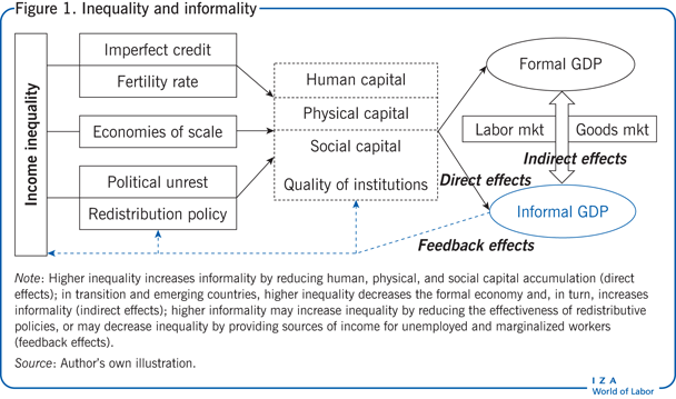
Higher inequality reduces capital accumulation and increases the informal economy, which creates additional employment opportunities for low-skilled and deprived people. Despite this positive feedback, informality raises problems for public finances and biases official statistics, reducing the effectiveness of redistributive policies. Policymakers should consider the links between inequality and informality because badly designed informality-reducing policies may increase inequality. However, convincing empirical evidence is still lacking and is usually limited to correlations rather than causal effects.
Source: https://wol.iza.org/articles/inequality-and-informality-in-transition-and-emerging-countries/long


Source: IB Geography: Course Book 2nd edition: Oxford IB Diploma Program
Synthesis (Sy), Evaluation (Ev) and Skills (Sk) opportunities
Use the content from this post to plan and answer the following question: ‘Explain how urban changes over time are affected by a place’s economic and demographic spatial interactions with other places’. 10 marks.
Use mark scheme on page 56 from the new syllabus guide (AO3).
No comments:
Post a Comment